It’s one of the biggies in Colorado: Independence Pass. A bucket-list ride, if you will, and no easy thing at that. It’s not really all that steep, with pitches generally between 6-7% and only small ramps above 8%. Rather, it’s the thin air that people comment on, as the ride starts in Aspen (from the west side) at about 7900′, and tops out a bit over 12,000′.
I was born and raised in Idaho, where people who live below about 5500′ are called “flatlanders.” This term should never be construed as a compliment. I believe it is because at low altitudes, such as those found along the coasts, the excessive amount of available oxygen for respiration can lead to proper brain function, and those of use who live higher up know that such things are overrated at best, and dangerous at worst.
Living at 7000′ as I do now, when I visit Idaho, I feel the thickness of their air as it moves into my lungs. I can ride like a champ there, except for the extra resistance their oppressive atmosphere creates. While visiting Mallorca, the ex-pro cyclist who rented me a bike, said that I must have lungs “the size of barrage ballons”, which I interpreted as a compliment about my moobs. And yes, they are impressive. Thanks for noticing.
The Pass, as it’s known locally (because at this altitude, few can muster the brain cells to spell “Independence” without assistance), beckons, but it hides a danger to all who face it: tourists in rental cars. Those readers of a certain age will recall that after some grisly crimes in Florida in the past century, rental car companies removed obvious logos and identifiers. Colorado, through a bureaucratic master stroke, has snuck in a simple way to detect rental cars: all fleet license plates are now red. True, large companies may also use fleet tags, but most rental cars don’t have construction company names pasted on their doors. Thus, even for oxygen-deprived locals, the red-tags can provide a simple way to identify dangerous cars and their drivers.
Now I understand that I should not generalize tourists and their loaner vehicles, nor should I disparage the companies who own the cars, but at the same time, I can’t for the life of me (or the life of any other highway user, for that matter) understand why people are able to rent Mustangs in Colorado in the Winter. NB: For those who have yet to visit the Centennial State, “winter” can happen any day of the year. Thus, your muscle car with rear-wheel drive is a hazard to other road users regardless of the month. In a similar vein, not all people who rent SUVs understand that Four Wheel Drive bears little or no correlation to Four Wheel Stop, and that driving at 70mph in the breakdown lane in a blinding snowstorm may not be the best long-term strategy for achieving a long and fruitful life.
Locals know about this, and that’s why they smile and wave at the jackasses buried to the tops of their fenders in snowbanks.
But, I digress. Let us return to The Pass, and let us celebrate those few, special days between the final plowing and annual re-discovery of the tarmac and the opening of the road to cars for Memorial Day Weekend.
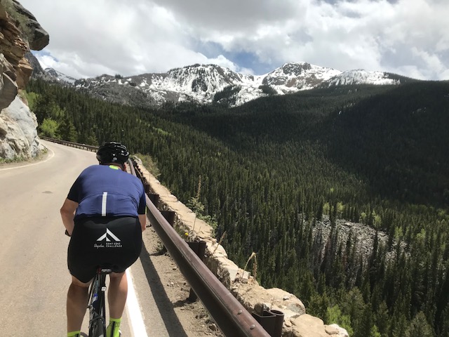
As with all great rides, there are many descriptions on the route, Strava segments, more Strava segments of the same part of the road but with a different name, and videos. Few mention actual details of the ride, such as the 6-7% ramp just past Difficult Campground to the winter closure gate. This bit of road is straight, and climbs through aspen groves. To the right, you can look down on the headwaters of the Roaring Fork River. This section, though deceptive, is actually quite challenging due to the steady, even grade and high altitude sun. It’s a test. If you get your tongue caught in your spokes here, turn around at the gate and head back to town. If not, ride on.
Once past the gate, you will encounter another ramp, much like the previous one, with a steady 6-7% grade to sap your legs. More aspen trees provide a bit of dappled sunshine, before the road chokes down to a narrow single lane section. If you’re fortunate enough to ride before cars are allowed, this is a great photo opportunity. If not, watch out for red plates.
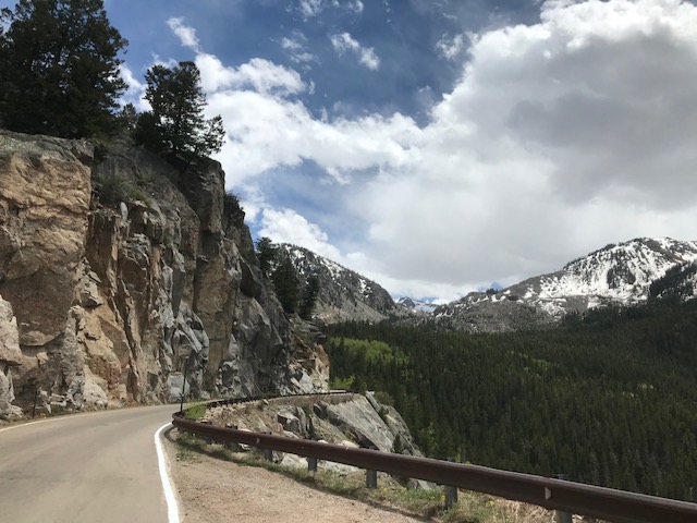
Here’s where semis get stuck and pay large fines.
After Weller Campground, the road pitch tapers a bit and the road itself moves away from the sidehill into a beautiful valley segment with pine trees and easy access to the river for foot-cooling. The road rolls along past several campgrounds, a second gate, and then a significant switchback. In fact, it’s the only switchback, as the large turn before the last pitch is too big to be considered a switchback. For those who have ridden in Europe, this is more like a slight jog in the road, but in Colorado, it counts as something akin to an Alpe d’Huez hairpin.
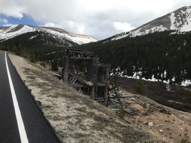
Not much farther, and the ghost town of Independence itself comes into view. If weather and time allow, this is a welcome respite from the climb and a chance to see the remains of a mining town. It’s actually really cool and worth stopping, and please put $5 in the donation box to help preserve the town and Pass road.
A bit past the last cabins, and you can glimpse the road cut to the top of the pass itself. Like a slash across the tundra, the road works its way up the final pitch, climbing away from your last opportunities to inhale anything useful, and towards the highest paved road in the area.
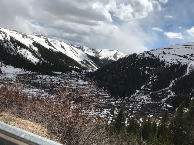
The last pitch is exposed to sun, wind, cosmic rays, and pikas, and offers you the chance to look back downvalley at the bit you just rode. For the most part, the grade is consistent between 6-7%, with tiny ramps to higher pitches. Don’t let these bother you, as they have little impact on your oxygen-deprived quads. Once you make the final turn, you are flooded with relief at finishing the climb.
However, this relief is short-lived as you realize the actual top is still some difference away, and the road snakes upwards toward a final 8% ramp just before the iconic sign which indicates the Continental Divide. Once you’ve dismounted your bike, your tears of relief roll either towards the Mississippi or towards the Bellagio fountains in Vegas.
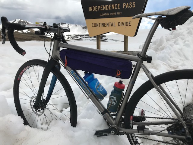
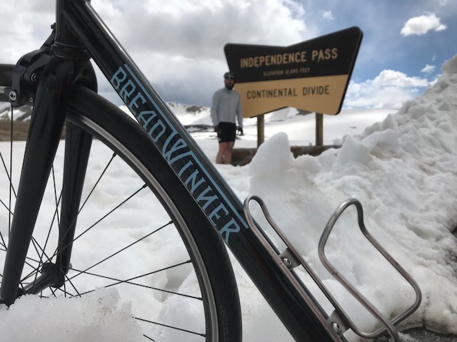
You are obligated by law to take a photo with this sign.
Once the photos are taken, you reach towards your pocket to pull out the arm warmers, vest, or jacket you brought along. This is the exciting part of the ride when you realize that your brain, not functioning at it’s finest, told you that since it’s nice and warm in town, you can leave these items behind, so you did just that.
You will soon realize that this high above sea level, it can get a bit brisk, but if the sun is out, you can stop periodically to rest your wooden fingers on the steel guard rail to try to thaw them out. At this altitude, sweat will freeze your Lycra to your body faster than it can evaporate, so as you descend towards warmer climes (like say, Arizona), you can enjoy a whole-body icecream headache. After this experience, you’ll be able to deal with your friends teasing you about always having enough spare clothes in your jersey pockets to retrace Shackleton’s route, but now you know what can happen to un-prepared cyclists.
Plus, you just rode one of the best climbs in Colorado, with spectacular views, and the flatlanders you call riding buddies never got any farther from sea level than a significant overpass, so you are clearly far superior. Embrace that knowledge and head back westward to Aspen for a well-deserved snack.